Summary
- 25,000ha high-potential brownfield copper-moly-silver-gold project associated with the Midcontinent Rift (“MCR”) in Ontario, Canada, which until 2021 had never been fully consolidated
- Recent porphyry and breccia drill holes as well as past copper production from two mines suggest the potential for larger intrusion related copper mineralization
- The project benefits from its strategic proximity to substantial infrastructure
Location and Ownership
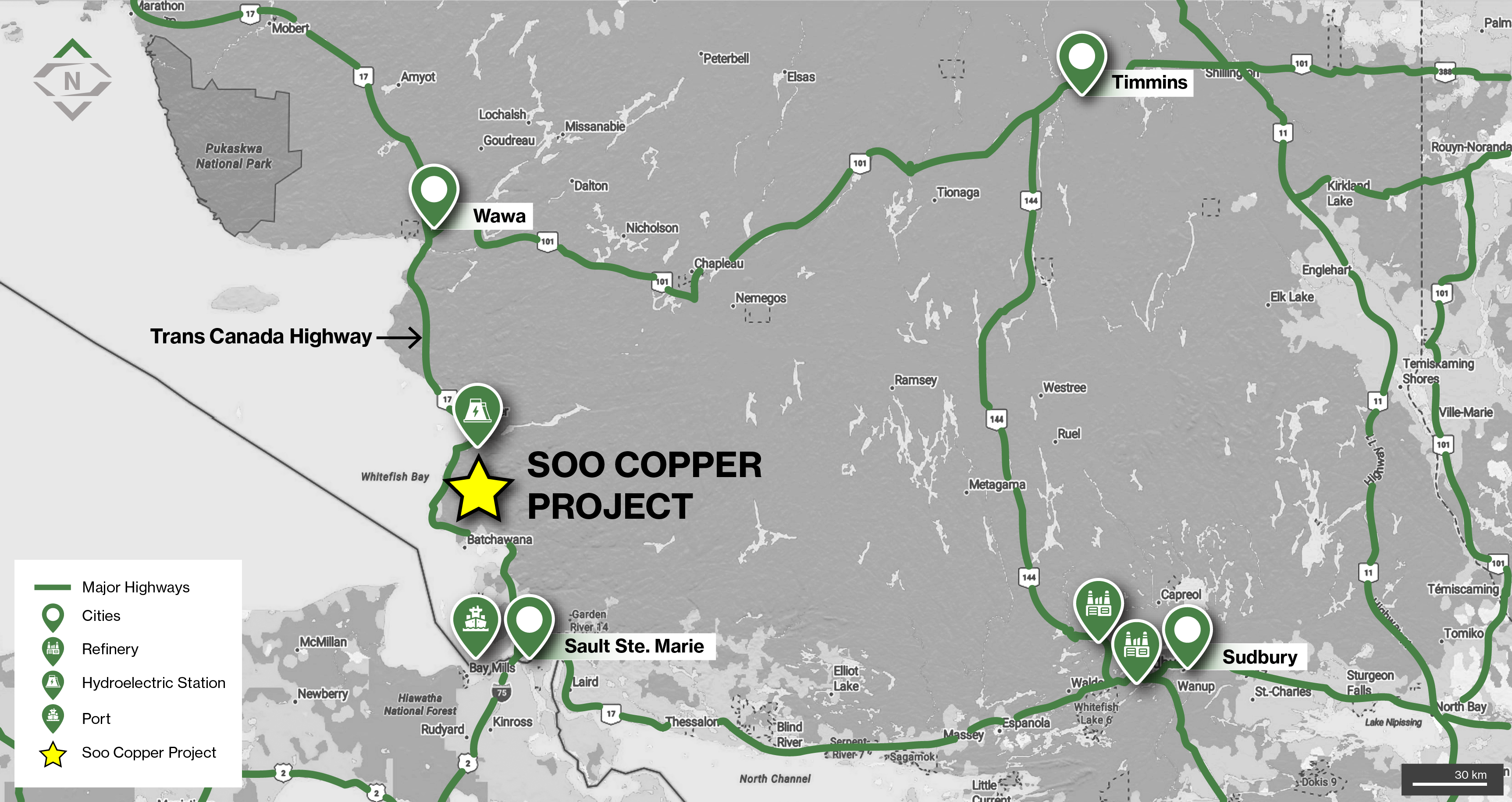
Location of the Soo Copper Project in Ontario, Canada located in proximity to significant infrastructure
- 100% owned and located in an area with a rich mining history, 30km from Batchewana Bay and situated between Wawa, Sault Ste. Marie, Sudbury and Timmins in Ontario, Canada
- The project is intersected by numerous highways and roads including the Trans-Canada Highway (Highway 17), which crosses the westernmost portion and provides major road connection to the city of Sault Ste. Marie
- The project is located 90km from the Port of Sault St Marie, and 40km from the Montreal River, which includes four hydroelectric dams and generating stations
- The project is also ideally located in proximity to two copper smelters outside of Sudbury
Geology
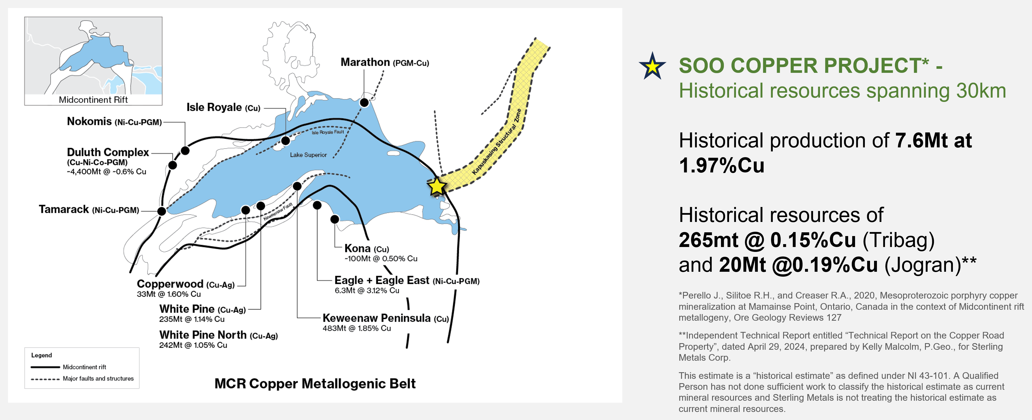
- Situated within the Mamainse Point Formation of the Keweenawan Group within the Proterozoic Southern Province, on the eastern edge of the MCR
- The MCR is home to numerous past-producing and present deposits around Lake Superior, including the prolific native copper deposits of the Keweenawan Peninsula in the U.S., mined for more than 150 years
- Porphyry mineralization at Soo Copper has been sourced to the same age range as the primary mineralizing event within the MCR1
- The Mamainse Point area has a long history of prospecting, exploration, and mining activity dating to the mid-1800’s with the production of copper, silver, and gold from the Copper Corp Mine from 1965 to 1972 and the Tribag Mine from 1965 to 1973, now known as the Soo Copper Project
- The Copper Corp mine reportedly produced 1.1Mt at 1.2% Cu while the Tribag Mine produced 6.5Mt tons at 2.75% Cu1
- Following closure of the mines, significant sections of the district were closed to staking by the Ontario Government
- As a result of this, and fragmented land ownership, the area has seen only sporadic mineral exploration since the 1970
1 Independent Technical Report entitled “Technical Report on the Copper Road Property”, dated April 29, 2024, prepared by Kelly Malcolm, P.Geo., for Sterling Metals Corp.
Exploration
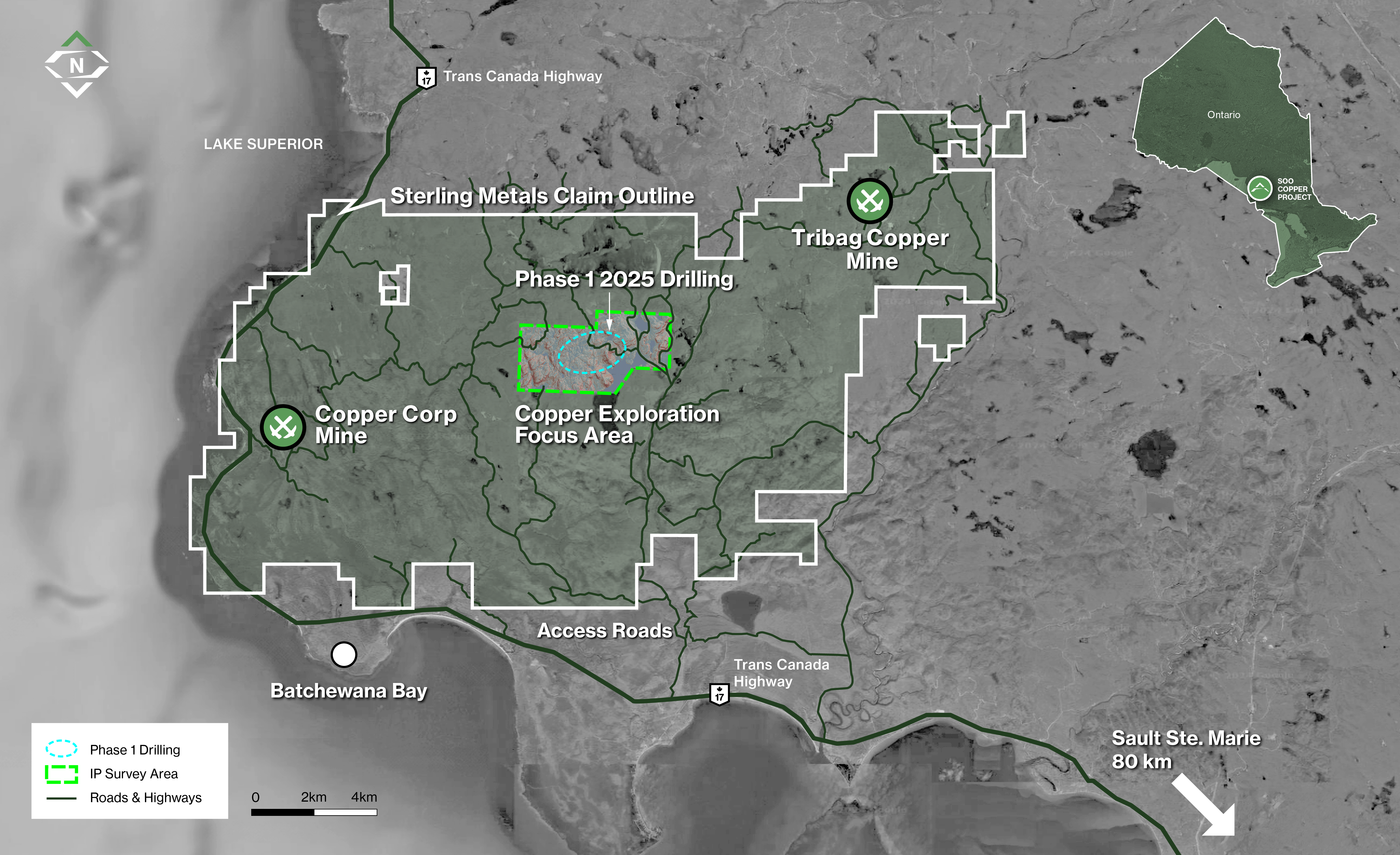 Figure 1: The Soo Copper Project located 80 km north of Sault Ste. Marie, Ontario, spans 25,000 hectares and extends 30 km in width. The Project benefits from proximity to key infrastructure and excellent accessibility, facilitating efficient exploration and development. The 2025 drilling program is concentrated in the central corridor of the Project, while historical mining activity at the Copper Corp and Tribag Breccia Mines is situated along the property's fringes.
- Since 2017, the previous operator, Copper Road Resources Inc., completed ~4,250m of drilling focused on confirming and extending mineralization at the past-producing Tribag Mine and the JR Zone (Jogran Porphyry), originally discovered by Phelps Dodge in the 1960s.
- As part of Sterling’s Phase I exploration (2024–2025), the Company completed soil sampling, airborne magnetics, LiDAR, new prospecting, digitized 200,000+ pages of historical data, and conducted a 5km x 3km 3D IP survey.
- In May 2025, Sterling successfully concluded its maiden drilling campaign. The program comprised four diamond drill holes totaling 1,789 metres. The first hole (MJ-25-01) intersected a continuous 359.3-metre zone grading 0.36% copper equivalent (CuEq) from near surface, including 75 metres at 0.56% CuEq. This discovery confirms the presence of a well-preserved, bornite-rich porphyry copper system, highlighting the project's significant mineral potential. Assay results for the remaining three holes are pending and will be released upon receipt.
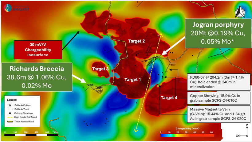 Figure 2: 2024 Chargeability Plan Map at 300m depth with clipped 30 mV/V isosurface chargeability anomalies highlighting four priority drill targets in the central corridor.
- Target 1 – Connection Between the Jogran Porphyry and Richards Breccia: A substantial charge anomaly has been detected in this area, which could indicate the presence of valuable mineralization. This target is located near historical drilling results but has not been directly tested in the past.
- Target 2 – Near-Surface Mineralization North of the Jorgan Porphyry and Richards Breccia: The largest charge anomaly on the property has been identified in this location, associated with low-resistivity and high-magnetic zones beneath the surface. Surface rock samples show the presence of copper-bearing minerals, yet this area remains untested by drilling.
- Target 3 – Additional Breccia and Porphyry Target North of Richards Breccia: Situated 200 meters north of historical drilling results that encountered high-grade copper, this target exhibits similar resistivity characteristics, suggesting the possibility of continued mineralization at depth.
- Target 4 – Surface Expression Area of the Large ZTEM Anomaly South of the Jogran Porphyry: This area, where the large ZTEM anomaly and resistivity features intersect at surface, has yielded some of the best soil and rock samples on the property to date, indicating high-grade copper mineralization. Past drilling nearby also intercepted valuable copper, with mineralization extending to significant depths.
 Figure 3: Hole locations from Sterling Metals inaugural drilling at the Soo Copper Project.
Technical Report
Qualified Person's Statement
Jeremy Niemi, P.Geo., Senior Vice President of Exploration and Evaluation to Sterling Metals, and a Qualified Person within the meaning of National Instrument 43-101 Standards of Disclosure for Minerals Projects, has reviewed and approved the technical information presented herein.